
Topografische Karte Valea Doftanei
Interaktive Karte
Klicken Sie auf die Karte, um die Höhe anzuzeigen.
Über diese Karte
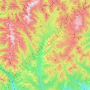
Name: Topografische Karte Valea Doftanei, Höhe, Relief.
Ort: Valea Doftanei, Prahova, Romania (45.24593 25.61392 45.48182 25.86762)
Durchschnittliche Höhe: 1.151 m
Minimale Höhe: 521 m
Maximale Höhe: 1.908 m
Andere topografische Karten
Klicken Sie auf eine Karte, um ihre Topografie, ihre Höhe und ihr Relief anzuzeigen.
Vălenii de Munte
Vălenii de Munte, Prahova, 106400, Romania
Durchschnittliche Höhe: 416 m
Valea Călugărească
Romania > Prahova > Valea Călugărească
Valea Călugărească, Prahova, Romania
Durchschnittliche Höhe: 154 m
Chiojdeanca
Romania > Prahova > Chiojdeanca
Chiojdeanca, Prahova, 107150, Romania
Durchschnittliche Höhe: 321 m
Cornu de Jos
Cornu de Jos, Cornu, Prahova, 107180, Romania
Durchschnittliche Höhe: 488 m
Iordăcheanu
Romania > Prahova > Iordăcheanu
Iordăcheanu, Prahova, 107310, Romania
Durchschnittliche Höhe: 194 m