
Topografische Karte Dorval
Interaktive Karte
Klicken Sie auf die Karte, um die Höhe anzuzeigen.
Über diese Karte
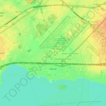
Name: Topografische Karte Dorval, Höhe, Relief.
Durchschnittliche Höhe: 29 m
Minimale Höhe: 14 m
Maximale Höhe: 48 m
Andere topografische Karten
Klicken Sie auf eine Karte, um ihre Topografie, ihre Höhe und ihr Relief anzuzeigen.
Pointe-Claire
Canada > Quebec > Urban agglomeration of Montreal
Pointe-Claire, Urban agglomeration of Montreal, Montreal (administrative region), Quebec, Canada
Durchschnittliche Höhe: 30 m
Montréal-Nord
Canada > Quebec > Urban agglomeration of Montreal > Montreal
Montréal-Nord, Montreal, Urban agglomeration of Montreal, Montreal (administrative region), Quebec, Canada
Durchschnittliche Höhe: 31 m
Montreal
Canada > Quebec > Urban agglomeration of Montreal
Montreal, Urban agglomeration of Montreal, Montreal (administrative region), Quebec, Canada
Durchschnittliche Höhe: 29 m
Mount Royal
Canada > Quebec > Urban agglomeration of Montreal > Montreal
Mount Royal, Montreal, Urban agglomeration of Montreal, Montreal (administrative region), Quebec, H3A 2B7, Canada
Durchschnittliche Höhe: 111 m
Parc-nature de la Pointe-aux-Prairies
Canada > Quebec > Urban agglomeration of Montreal > Montreal
Parc-nature de la Pointe-aux-Prairies, Rue Trefflé-Berthiaume, Rivière-des-Prairies, Rivière-des-Prairies–Pointe-aux-Trembles, Montreal, Urban agglomeration of Montreal, Montreal (06), Quebec, H1C 1B3, Canada
Durchschnittliche Höhe: 13 m
Dollard-des-Ormeaux
Canada > Quebec > Urban agglomeration of Montreal
Dollard-des-Ormeaux, Urban agglomeration of Montreal, Montreal (06), Quebec, Canada
Durchschnittliche Höhe: 34 m