
Topografische Karte Signal Hill National Historic Site
Interaktive Karte
Klicken Sie auf die Karte, um die Höhe anzuzeigen.
Über diese Karte
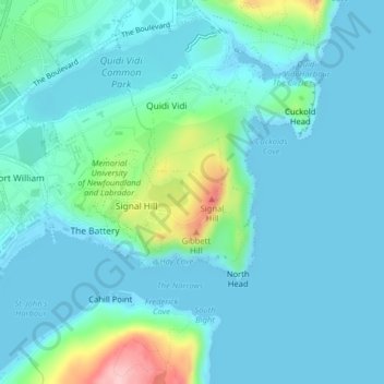
Name: Topografische Karte Signal Hill National Historic Site, Höhe, Relief.
Durchschnittliche Höhe: 29 m
Minimale Höhe: -1 m
Maximale Höhe: 175 m
Andere topografische Karten
Klicken Sie auf eine Karte, um ihre Topografie, ihre Höhe und ihr Relief anzuzeigen.
Newfound Pond
Canada > Newfoundland and Labrador > St. John's
Newfound Pond, St. John's, Newfoundland, Newfoundland and Labrador, Canada
Durchschnittliche Höhe: 157 m
Cape Spear
Canada > Newfoundland and Labrador > St. John's
Cape Spear, St. John's, Newfoundland, Newfoundland and Labrador, Canada
Durchschnittliche Höhe: 7 m
Cape Bay
Canada > Newfoundland and Labrador > St. John's
Cape Bay, St. John's, Newfoundland, Newfoundland and Labrador, Canada
Durchschnittliche Höhe: 21 m
Wigmore
Canada > Newfoundland and Labrador > St. John's
Wigmore, St. John's, Newfoundland, Newfoundland and Labrador, Canada
Durchschnittliche Höhe: 118 m
Blackhead
Canada > Newfoundland and Labrador > St. John's > Blackhead
Blackhead, St. John's, Newfoundland and Labrador, Canada
Durchschnittliche Höhe: 48 m