
Topografische Karte Palafrugell
Interaktive Karte
Klicken Sie auf die Karte, um die Höhe anzuzeigen.
Über diese Karte
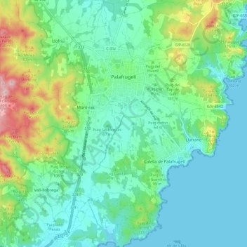
Name: Topografische Karte Palafrugell, Höhe, Relief.
Ort: Palafrugell, Baix Empordà, Gerona, Catalonië, Spanje (41.86082 3.11721 41.94429 3.21934)
Durchschnittliche Höhe: 70 m
Minimale Höhe: 0 m
Maximale Höhe: 288 m
Andere topografische Karten
Klicken Sie auf eine Karte, um ihre Topografie, ihre Höhe und ihr Relief anzuzeigen.
Begur
Spanje > Catalonië > Baix Empordà
Begur, Baix Empordà, Gerona, Catalonië, 17213, Spanje
Durchschnittliche Höhe: 77 m
Calonge
Spanje > Catalonië > Baix Empordà > Calonge i Sant Antoni
Calonge, Calonge i Sant Antoni, Baix Empordà, Gerona, Catalonië, 17251, Spanje
Durchschnittliche Höhe: 116 m
Castell-Platja d'Aro
Spanje > Catalonië > Baix Empordà
Castell-Platja d'Aro, Baix Empordà, Gerona, Catalonië, 17248, Spanje
Durchschnittliche Höhe: 48 m
Castell d'Aro
Spanje > Catalonië > Baix Empordà > Castell-Platja d'Aro
Castell d'Aro, Castell-Platja d'Aro, Baix Empordà, Gerona, Catalonië, 17248, Spanje
Durchschnittliche Höhe: 94 m
l'Estartit
Spanje > Catalonië > Baix Empordà > Torroella de Montgrí
l'Estartit, Torroella de Montgrí, Baix Empordà, Gerona, Catalonië, 17130, Spanje
Durchschnittliche Höhe: 34 m
Torroella de Montgrí
Spanje > Catalonië > Baix Empordà
Torroella de Montgrí, Baix Empordà, Gerona, Catalonië, 17130, Spanje
Durchschnittliche Höhe: 34 m
Pals
Spanje > Catalonië > Baix Empordà
Pals, Baix Empordà, Gerona, Catalonië, 17256, Spanje
Durchschnittliche Höhe: 33 m