
Spenden
Topografische Karte Chimney Rock
Klicken Sie auf die Karte, um die Höhe anzuzeigen.
Spenden
Über diese Karte
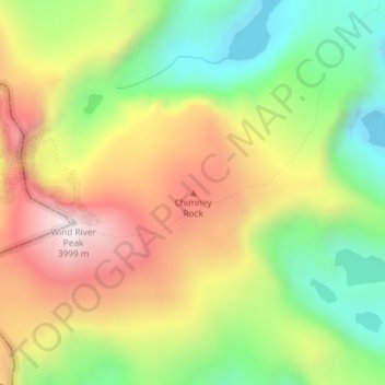
Name: Topografische Karte Chimney Rock, Höhe, Relief.
Ort: Chimney Rock, Fremont County, Wyoming, United States (42.71058 -109.11680 42.71068 -109.11670)
Durchschnittliche Höhe: 3.627 m
Minimale Höhe: 3.288 m
Maximale Höhe: 4.014 m
Spenden
Andere topografische Karten
Klicken Sie auf eine Karte, um ihre Topografie, ihre Höhe und ihr Relief anzuzeigen.
Dubois
United States > Wyoming > Fremont County
Dubois is located at 43°32′9″N 109°38′9″W / 43.53583°N 109.63583°W / 43.53583; -109.63583 (43.535936, -109.635915) and an elevation of 2115 m (6940 ft). The Wind River runs through the town.
Durchschnittliche Höhe: 2.167 m
Spenden
Sinks Canyon State Park
United States > Wyoming > Fremont County > Lander
Durchschnittliche Höhe: 2.133 m
Spenden
Spenden
Dubois
United States > Wyoming > Fremont County
Dubois is located at 43°32′9″N 109°38′9″W / 43.53583°N 109.63583°W / 43.53583; -109.63583 (43.535936, -109.635915) and an elevation of 2115 m (6940 ft). The Wind River runs through the town.
Durchschnittliche Höhe: 2.167 m
Spenden