
Vielen Dank für die Unterstützung dieser Website ❤️
Spenden
Spenden
Topografische Karte Lamar
Klicken Sie auf die Karte, um die Höhe anzuzeigen.
Vielen Dank für die Unterstützung dieser Website ❤️
Spenden
Spenden
Über diese Karte
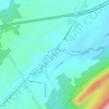
Name: Topografische Karte Lamar, Höhe, Relief.
Durchschnittliche Höhe: 288 m
Minimale Höhe: 224 m
Maximale Höhe: 602 m
Vielen Dank für die Unterstützung dieser Website ❤️
Spenden
Spenden
Andere topografische Karten
Klicken Sie auf eine Karte, um ihre Topografie, ihre Höhe und ihr Relief anzuzeigen.
Nittany Valley
United States > Pennsylvania > Clinton County > Porter Township
Nittany Valley is in the western part of the Ridge and Valley province of the Appalachian Mountains. During the Appalachian orogeny, the sedimentary rock layers folded up into the Nittany Arch anticline. The arch was an ancient Himalayan scale mountain that towered above what is now the valley. The oldest rock…
Durchschnittliche Höhe: 362 m