
Topografische Karte Clallam Bay
Interaktive Karte
Klicken Sie auf die Karte, um die Höhe anzuzeigen.
Über diese Karte
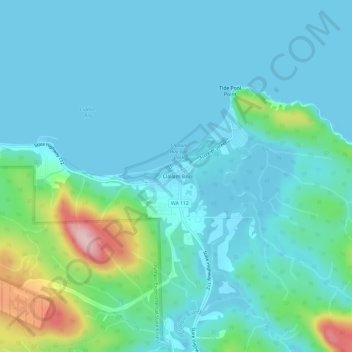
Name: Topografische Karte Clallam Bay, Höhe, Relief.
Ort: Clallam Bay, Clallam County, Washington, United States (48.23399 -124.28070 48.27399 -124.24070)
Durchschnittliche Höhe: 39 m
Minimale Höhe: -2 m
Maximale Höhe: 234 m
Andere topografische Karten
Klicken Sie auf eine Karte, um ihre Topografie, ihre Höhe und ihr Relief anzuzeigen.
Sequim
United States > Washington > Clallam County
Sequim, Clallam County, Washington, United States
Durchschnittliche Höhe: 88 m
Port Angeles
United States > Washington > Clallam County
Port Angeles, Clallam County, Washington, 98362, United States
Durchschnittliche Höhe: 27 m
Lake Crescent
United States > Washington > Clallam County
Lake Crescent, Clallam County, Washington, United States
Durchschnittliche Höhe: 564 m
Solmar Lake Dam
United States > Washington > Clallam County
Solmar Lake Dam, Clallam County, Washington, United States
Durchschnittliche Höhe: 80 m
Sunrise View Point
United States > Washington > Clallam County
Sunrise View Point, Hurricane Ridge to Switchback Trail, Clallam County, Washington, United States
Durchschnittliche Höhe: 1.397 m
Lake Crescent
United States > Washington > Clallam County
Lake Crescent, Clallam County, Washington, United States
Durchschnittliche Höhe: 564 m