
Topografische Karte Ruxton
Interaktive Karte
Klicken Sie auf die Karte, um die Höhe anzuzeigen.
Über diese Karte
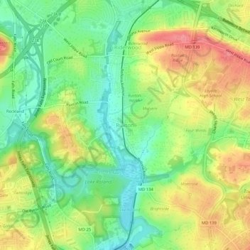
Name: Topografische Karte Ruxton, Höhe, Relief.
Ort: Ruxton, Baltimore County, Maryland, 21139, United States (39.37804 -76.66486 39.41804 -76.62486)
Durchschnittliche Höhe: 105 m
Minimale Höhe: 64 m
Maximale Höhe: 157 m
Andere topografische Karten
Klicken Sie auf eine Karte, um ihre Topografie, ihre Höhe und ihr Relief anzuzeigen.
Wetherfield
United States > Maryland > Baltimore County
Wetherfield, Baltimore County, Maryland, United States
Durchschnittliche Höhe: 96 m
Towson
United States > Maryland > Baltimore County
Towson, Baltimore County, Maryland, 21252, United States
Durchschnittliche Höhe: 101 m
Dundalk
United States > Maryland > Baltimore County
Dundalk, Baltimore County, Maryland, 21222, United States
Durchschnittliche Höhe: 33 m
Lutherville
United States > Maryland > Baltimore County
Lutherville, Baltimore County, Maryland, 21204, United States
Durchschnittliche Höhe: 117 m
Parkville
United States > Maryland > Baltimore County
Parkville, Baltimore County, Maryland, 21234, United States
Durchschnittliche Höhe: 91 m
Baltimore Highlands
United States > Maryland > Baltimore County
Baltimore Highlands, Baltimore County, Maryland, 21225, United States
Durchschnittliche Höhe: 21 m
Baldwin
United States > Maryland > Baltimore County
Baldwin, Baltimore County, Maryland, 21082, United States
Durchschnittliche Höhe: 130 m
White Marsh
United States > Maryland > Baltimore County > White Marsh
White Marsh, Baltimore County, Maryland, United States
Durchschnittliche Höhe: 39 m
Middle River
United States > Maryland > Baltimore County > Middle River
Middle River, Baltimore County, Maryland, 21220, United States
Durchschnittliche Höhe: 13 m
Dundalk
United States > Maryland > Baltimore County > Dundalk
Dundalk, Baltimore County, Maryland, 21222, United States
Durchschnittliche Höhe: 6 m
Pikesville
United States > Maryland > Baltimore County > Pikesville
Pikesville, Baltimore County, Maryland, United States
Durchschnittliche Höhe: 135 m
Butler
United States > Maryland > Baltimore County > Butler
Butler, Baltimore County, Maryland, 21023, United States
Durchschnittliche Höhe: 134 m
Carney
United States > Maryland > Baltimore County > Oakleigh
Carney, Oakleigh, Baltimore County, Maryland, United States
Durchschnittliche Höhe: 103 m
Arbutus
United States > Maryland > Baltimore County > Arbutus
Arbutus, Baltimore County, Maryland, United States
Durchschnittliche Höhe: 42 m
Essex
United States > Maryland > Baltimore County > Essex
Essex, Baltimore County, Maryland, 21221, United States
Durchschnittliche Höhe: 6 m
Towson
United States > Maryland > Baltimore County > Riderwood
Towson, Riderwood, Baltimore County, Maryland, United States
Durchschnittliche Höhe: 114 m
Catonsville
United States > Maryland > Baltimore County > Catonsville
Catonsville, Baltimore County, Maryland, 21228, United States
Durchschnittliche Höhe: 104 m
Bird River
United States > Maryland > Baltimore County > Bowleys Quarters
Bird River, Bowleys Quarters, Baltimore County, Maryland, United States
Durchschnittliche Höhe: 4 m
Glen Falls
United States > Maryland > Baltimore County > Glen Falls
Glen Falls, Baltimore County, Maryland, United States
Durchschnittliche Höhe: 167 m
Parkville
United States > Maryland > Baltimore County > Parkville
Parkville, Baltimore County, Maryland, 21234, United States
Durchschnittliche Höhe: 111 m
Catonsville
United States > Maryland > Baltimore County > Catonsville
Catonsville, Baltimore County, Maryland, United States
Durchschnittliche Höhe: 105 m
Carney
United States > Maryland > Baltimore County
Carney, Baltimore County, Maryland, 21234, United States
Durchschnittliche Höhe: 91 m