
Topografische Karte Mount Elbrus (West Summit)
Interaktive Karte
Klicken Sie auf die Karte, um die Höhe anzuzeigen.
Über diese Karte
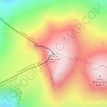
Name: Topografische Karte Mount Elbrus (West Summit), Höhe, Relief.
Durchschnittliche Höhe: 5.164 m
Minimale Höhe: 4.572 m
Maximale Höhe: 5.632 m
As Elbrus is located in the Northern Hemisphere, the summer period takes place from June to mid-September, with an average of 50% of sunny days favorable to the ascent of the summit. However, the winds, dominated by westerly air masses, can turn violent and temperatures drop very quickly. Above 4000 meters above sea level, even in summer, blizzard conditions with near zero visibility can develop. It is not uncommon for the wind to exceed 100 km/h. In winter, the temperature can drop below −50° at the top. Precipitation increases with altitude.
Andere topografische Karten
Klicken Sie auf eine Karte, um ihre Topografie, ihre Höhe und ihr Relief anzuzeigen.
Западное ребро
Russia > Karachay-Cherkessia > Karachayevsky District
Западное ребро, Хурзукское сельское поселение, Karachayevsky District, Karachay-Cherkessia, North Caucasian Federal District, Russia
Durchschnittliche Höhe: 5.130 m
Западное ребро
Russia > Karachay-Cherkessia > Karachayevsky District
Западное ребро, Хурзукское сельское поселение, Karachayevsky District, Karachay-Cherkessia, North Caucasian Federal District, Russia
Durchschnittliche Höhe: 5.057 m