
Spenden
Topografische Karte Lena River
Klicken Sie auf die Karte, um die Höhe anzuzeigen.
Spenden
Lena River
Originating at an elevation of 1,640 meters (5,381 ft) at its source in the Baikal Mountains south of the Central Siberian Plateau, 7 kilometres (4 mi) west of Lake Baikal, the Lena flows northeast across the Lena-Angara Plateau, being joined by the Kirenga, Vitim and Olyokma. From Yakutsk it enters the Central Yakutian Lowland and flows north until joined by its right-hand tributary the Aldan and its most important left-hand tributary, the Vilyuy. After that, it bends westward and northward, flowing between the Kharaulakh Range, part of the Verkhoyansk Range, in the east and the Chekanovsky Ridge in the west. Making its way nearly due north it expands into a large delta and ends in the Laptev Sea, a division of the Arctic Ocean, south-west of the New Siberian Islands. The Lena Delta is 30,000 square kilometres (12,000 sq mi) in area, being traversed by seven main branches, the most important being the Bykovsky channel, farthest east.
Spenden
Über diese Karte
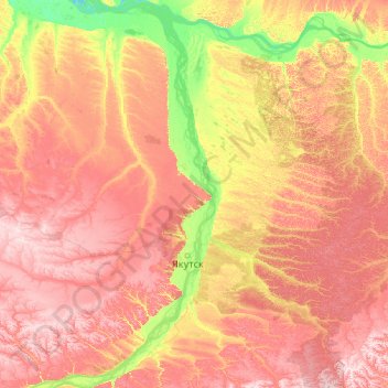
Name: Topografische Karte Lena River, Höhe, Relief.
Durchschnittliche Höhe: 182 m
Minimale Höhe: 65 m
Maximale Höhe: 376 m
Spenden
Andere topografische Karten
Klicken Sie auf eine Karte, um ihre Topografie, ihre Höhe und ihr Relief anzuzeigen.