
Topografische Karte Medstead
Klicken Sie auf die Karte, um die Höhe anzuzeigen.
Medstead
Medstead is a village and civil parish in the East Hampshire district of Hampshire, England. Its nearest town is Alton, which lies 4.3 miles (6.9 km) northeast of the village. According to the 2011 census, the village had a population of 2,036 people. The parish covers an area of 1,536 acres (622 ha) and has an average elevation of approximately 600 feet (180 m) above sea level. One of the county's high points at 716 feet (218 m), King's Hill, runs through Medstead and Bentworth.
Über diese Karte
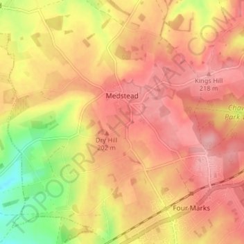
Name: Topografische Karte Medstead, Höhe, Relief.
Ort: Medstead, East Hampshire, Hampshire, England, United Kingdom (51.10494 -1.09543 51.14600 -1.03704)
Durchschnittliche Höhe: 186 m
Minimale Höhe: 114 m
Maximale Höhe: 224 m
Andere topografische Karten
Klicken Sie auf eine Karte, um ihre Topografie, ihre Höhe und ihr Relief anzuzeigen.
Liphook
United Kingdom > England > Hampshire > East Hampshire
In Samuel Lewis's 1831 Topographical Dictionary of England, he referred to Liphook as a hamlet in the parish of Bramshott.
Durchschnittliche Höhe: 121 m
Rowland's Copse, Red Hill
United Kingdom > England > Hampshire > East Hampshire > Rowlands Castle
Durchschnittliche Höhe: 42 m
Cold Ash Hill
United Kingdom > England > Hampshire > East Hampshire > Bramshott
Durchschnittliche Höhe: 126 m
North Street
United Kingdom > England > Hampshire > East Hampshire > Ropley
Durchschnittliche Höhe: 143 m
Frith End
United Kingdom > England > Hampshire > East Hampshire > Frith End
Durchschnittliche Höhe: 87 m
Hartley Mauditt
United Kingdom > England > Hampshire > East Hampshire > Hartley Mauditt
Durchschnittliche Höhe: 123 m
Blacknest
United Kingdom > England > Hampshire > East Hampshire > Binsted
Durchschnittliche Höhe: 103 m
Flexcombe
United Kingdom > England > Hampshire > East Hampshire > West Liss
Durchschnittliche Höhe: 91 m
Comp
United Kingdom > England > Hampshire > East Hampshire > Upper Farringdon
Durchschnittliche Höhe: 126 m
Bramshott Common
United Kingdom > England > Hampshire > East Hampshire > Bramshott
Durchschnittliche Höhe: 148 m
Gilbert Street
United Kingdom > England > Hampshire > East Hampshire > Ropley
Durchschnittliche Höhe: 151 m
Blendworth
United Kingdom > England > Hampshire > East Hampshire > Horndean
Durchschnittliche Höhe: 86 m
Havant Thicket
United Kingdom > England > Hampshire > East Hampshire > Rowlands Castle
Durchschnittliche Höhe: 48 m
Ludshott Common
United Kingdom > England > Hampshire > East Hampshire > Bramshott
Durchschnittliche Höhe: 162 m
Ditcham Woods.
United Kingdom > England > Hampshire > East Hampshire > Buriton
Durchschnittliche Höhe: 136 m
New Copse
United Kingdom > England > Hampshire > East Hampshire > Bentworth
Durchschnittliche Höhe: 184 m
Merryfield
United Kingdom > England > Hampshire > East Hampshire > West Tisted
Durchschnittliche Höhe: 164 m
Neatham
United Kingdom > England > Hampshire > East Hampshire > Alton > Holybourne
Durchschnittliche Höhe: 122 m
Froxfield Green
United Kingdom > England > Hampshire > East Hampshire > High Cross
Durchschnittliche Höhe: 177 m
Hattingley
United Kingdom > England > Hampshire > East Hampshire > Medstead
Durchschnittliche Höhe: 176 m
Coldhayes
United Kingdom > England > Hampshire > East Hampshire > Coldhayes
Durchschnittliche Höhe: 99 m