
Spenden
Topografische Karte Kolhapur
Klicken Sie auf die Karte, um die Höhe anzuzeigen.
Spenden
Kolhapur
Kolhapur is an inland city located in south-west Maharashtra state, 385 km (239 mi) south of Mumbai and 237 km (147 mi) south of Pune, 656 km (408 mi) north-west of Bengaluru, 539 km (335 mi) west of Hyderabad and 49 km (30 mi) west of Sangli city. Within Maharashtra, Kolhapur's nearest cities and towns are Ichalkaranji 30 km (19 mi), Jaysingpur 40 km (25 mi), Kagal 20 km (12 mi), Belgaum 114 km (71 mi). It lies in the Sahayadri mountains in the Western Ghats at an elevation of 569 m (1,867 ft). Tambraparni river dam near Umgaon village is close by, as also are Radhanagari and Kalambawadi dams. Panhala 21 km (13 mi) and Jyotiba Temple 19 km (12 mi) are in the vicinity of Kolhapur too.
Spenden
Über diese Karte
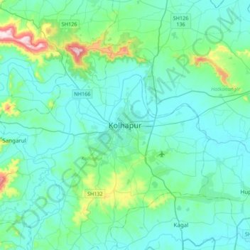
Name: Topografische Karte Kolhapur, Höhe, Relief.
Durchschnittliche Höhe: 592 m
Minimale Höhe: 532 m
Maximale Höhe: 971 m
Spenden
Andere topografische Karten
Klicken Sie auf eine Karte, um ihre Topografie, ihre Höhe und ihr Relief anzuzeigen.