Geolokalisieren
👉 Easily get elevation data in JSON, GeoTIFF and KML formats using Elevation API
Vielen Dank für die Unterstützung dieser Website ❤️
Spenden

Topografische Karte Thadlaskein

Klicken Sie auf die Karte, um die Höhe anzuzeigen.

👉 Easily get elevation data in JSON, GeoTIFF and KML formats using Elevation API
Vielen Dank für die Unterstützung dieser Website ❤️
Spenden

Über diese Karte

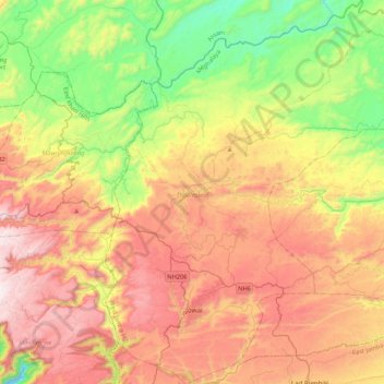
Name: Topografische Karte Thadlaskein, Höhe, Relief.

Ort: Thadlaskein, West Jaintia Hills, Meghalaya, 793151, India (25.36830 92.09826 25.75473 92.48692)

Durchschnittliche Höhe: 1.135 m

Minimale Höhe: 663 m

Maximale Höhe: 1.684 m

👉 Easily get elevation data in JSON, GeoTIFF and KML formats using Elevation API
Vielen Dank für die Unterstützung dieser Website ❤️
Spenden

Andere topografische Karten

Klicken Sie auf eine Karte, um ihre Topografie, ihre Höhe und ihr Relief anzuzeigen.

Sohra (Cherrapunji)

India > Meghalaya > Shella Bholaganj

It has an average elevation of 1,430 metres (4,690 ft) and sits on a plateau in the southern part of the Khasi Hills, facing the plains of Bangladesh. The plateau rises 660 meters above the surrounding valleys.

Durchschnittliche Höhe: 1.169 m

Khasi Hills

India > Meghalaya > Mawshynrut

Durchschnittliche Höhe: 349 m

Mawsynram

India > Meghalaya > Mawsynram

Durchschnittliche Höhe: 1.028 m

River Umiam

India > Meghalaya > Sohiong

Durchschnittliche Höhe: 1.440 m

Vielen Dank für die Unterstützung dieser Website ❤️
Spenden

Sohsarat

India > Meghalaya > Shella Bholaganj > Nongwar

Durchschnittliche Höhe: 372 m

Byrnihat

India > Meghalaya > Umling

Durchschnittliche Höhe: 171 m

Pyndem Mawthawiong

India > Meghalaya > Mawkyrwat

Durchschnittliche Höhe: 1.573 m

Nongstoin

India > Meghalaya > Nongstoin

Nongstoin is located at 25°31′N 91°16′E / 25.52°N 91.27°E / 25.52; 91.27. It has an average elevation of 1409 metres (4622 feet).e

Durchschnittliche Höhe: 1.408 m

Vielen Dank für die Unterstützung dieser Website ❤️
Spenden

Suktia

India > Meghalaya > Shella Bholaganj

Durchschnittliche Höhe: 486 m

Nongthymmai

India > Meghalaya > Shella Bholaganj

Durchschnittliche Höhe: 1.123 m

Raliang

India > Meghalaya > Laskein

Durchschnittliche Höhe: 1.239 m

Umroi

India > Meghalaya > Umsning

Durchschnittliche Höhe: 914 m

Vielen Dank für die Unterstützung dieser Website ❤️
Spenden

Nongjrong

India > Meghalaya > Mawkynrew

Durchschnittliche Höhe: 1.176 m

Umiew

India > Meghalaya > Khatarshnong Laitkroh > Smit

Durchschnittliche Höhe: 1.712 m

Shillong

India > Meghalaya > Mylliem > Shillong

Durchschnittliche Höhe: 1.843 m

Nongtrai

India > Meghalaya > Mawsynram

Durchschnittliche Höhe: 386 m

Vielen Dank für die Unterstützung dieser Website ❤️
Spenden

river

India > Meghalaya > Shella Bholaganj

Durchschnittliche Höhe: 437 m

Riwai Village

India > Meghalaya > Pynursla > Nohwet Village

Durchschnittliche Höhe: 430 m

Jowai

India > Meghalaya > Thadlaskein

Jowai (IPA: ʤəʊˈwaɪ) is the headquarters of the West Jaintia Hills district of the state of Meghalaya, India, and is home to the Pnar, a sub-tribe of the Khasi people. It is located on a plateau surrounded on three sides by the Myntdu river bordering Bangladesh to the south (about 50 km from the…

Durchschnittliche Höhe: 1.332 m

Thadlaskein

India > Meghalaya > Thadlaskein

Durchschnittliche Höhe: 1.349 m

Vielen Dank für die Unterstützung dieser Website ❤️
Spenden

Nongpoh

India > Meghalaya > Umling

Durchschnittliche Höhe: 593 m

Shillong

India > Meghalaya > Mylliem

HQ Eastern Air Command (HQ, EAC) was shifted to Shillong on 10 Jun 63 from Kolkata and housed in the old buildings located at Nonglyer village at Upper Shillong, some 10 km from (Lower) Shillong, but at a greater altitude of around 6,000 feet AMSL. Initially a British military base, it was taken over by No. 58…

Durchschnittliche Höhe: 1.351 m

Mawdiangdiang

India > Meghalaya > Mawpat

Durchschnittliche Höhe: 1.402 m

Sohkhmi

India > Meghalaya > Shella Bholaganj

Durchschnittliche Höhe: 443 m

Vielen Dank für die Unterstützung dieser Website ❤️
Spenden

Sumer Village

India > Meghalaya > Umsning

Durchschnittliche Höhe: 971 m

Nongwar

India > Meghalaya > Shella Bholaganj

Durchschnittliche Höhe: 415 m

Nartiang

India > Meghalaya > Thadlaskein

Durchschnittliche Höhe: 1.222 m

Laitkroh

India > Meghalaya > Khatarshnong Laitkroh

Durchschnittliche Höhe: 1.792 m

Vielen Dank für die Unterstützung dieser Website ❤️
Spenden

Sohmynting

India > Meghalaya > Thadlaskein

Durchschnittliche Höhe: 1.407 m

Umling

India > Meghalaya > Umling

Durchschnittliche Höhe: 379 m

Bapung

India > Meghalaya > Jaintia Hills > Bapung

Durchschnittliche Höhe: 1.305 m

Elephant Falls

India > Meghalaya > Sohiong

Durchschnittliche Höhe: 1.724 m

Vielen Dank für die Unterstützung dieser Website ❤️
Spenden

Shillong

India > Meghalaya > Mylliem

HQ Eastern Air Command (HQ, EAC) was shifted to Shillong on 10 Jun 63 from Kolkata and housed in the old buildings located at Nonglyer village at Upper Shillong, some 10 km from (Lower) Shillong, but at a greater altitude of around 6,000 feet AMSL. Initially a British military base, it was taken over by No. 58…

Durchschnittliche Höhe: 1.351 m

Mawsynram

India > Meghalaya > Mawsynram

Mawsynram is located at 25° 18′ N, 91° 35′ E, at an altitude of about 1,400 meters (4,600 ft), 15 km west of Cherrapunji, in the Khasi Hills in the state of Meghalaya (India).

Durchschnittliche Höhe: 1.028 m

Shillong

India > Meghalaya > Mylliem

HQ Eastern Air Command (HQ, EAC) was shifted to Shillong on 10 June 1963 from Kolkata and housed in the old buildings located at Nonglyer village at Upper Shillong, some 10 km (6.2 mi) from (Lower) Shillong, but at a greater altitude of around 1,800 metres (6,000 ft) AMSL. Initially a British military base, it…

Durchschnittliche Höhe: 1.351 m

Vielen Dank für die Unterstützung dieser Website ❤️
Spenden

Shillong

India > Meghalaya > Mylliem

HQ Eastern Air Command (HQ, EAC) was shifted to Shillong on 10 Jun 63 from Kolkata and housed in the old buildings located at Nonglyer village at Upper Shillong, some 10 km from (Lower) Shillong, but at a greater altitude of around 6,000 feet AMSL. Initially a British military base, it was taken over by No. 58…

Durchschnittliche Höhe: 1.351 m

Mawsynram

India > Meghalaya > Mawsynram

Mawsynram is located at 25° 18′ N, 91° 35′ E, at an altitude of about 1,400 meters (4,600 ft), 15 km west of Cherrapunji, in the Khasi Hills in the state of Meghalaya (India).

Durchschnittliche Höhe: 1.028 m

Sohkhmi

India > Meghalaya > Shella Bholaganj

Durchschnittliche Höhe: 443 m

Vielen Dank für die Unterstützung dieser Website ❤️
Spenden

Sohbar Village

India > Meghalaya > Shella Bholaganj

Durchschnittliche Höhe: 509 m

Mawmluh

India > Meghalaya > Shella Bholaganj

Durchschnittliche Höhe: 1.128 m

Laitlum Grand Canyon

India > Meghalaya > Pynursla

Durchschnittliche Höhe: 1.482 m

Byrnihat

India > Meghalaya > Umling

Durchschnittliche Höhe: 171 m

Vielen Dank für die Unterstützung dieser Website ❤️
Spenden

Tura

India > Meghalaya > Gambegre

Tura is located at 25°31′N 90°13′E / 25.52°N 90.22°E / 25.52; 90.22. It has an average elevation of 349 metres (1145 feet). Its climate is a Humid Subtropical climate (Köppen climate classification: Cwa).

Durchschnittliche Höhe: 408 m

Nartiang

India > Meghalaya > Thadlaskein

Durchschnittliche Höhe: 1.222 m

Sohra (Cherrapunji)

India > Meghalaya > Shella Bholaganj

It has an average elevation of 1,430 metres (4,690 ft) and sits on a plateau in the southern part of the Khasi Hills, facing the plains of Bangladesh. The plateau rises 660 meters above the surrounding valleys.

Durchschnittliche Höhe: 1.169 m