
Topografische Karte Newport
Interaktive Karte
Klicken Sie auf die Karte, um die Höhe anzuzeigen.
Über diese Karte
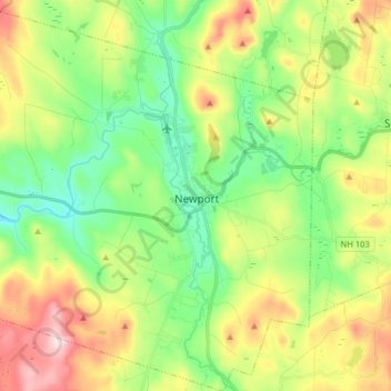
Name: Topografische Karte Newport, Höhe, Relief.
Durchschnittliche Höhe: 339 m
Minimale Höhe: 187 m
Maximale Höhe: 600 m
Newport is drained by the Sugar River and its South Branch, with the town center at their confluence. The North Branch joins the Sugar River north of Newport village and east of North Newport. The highest point in town is along its southern border, where an unnamed ridge has an elevation of approximately 1,920 feet (590 m) above sea level.