
Topografische Karte Arthur's Pass
Interaktive Karte
Klicken Sie auf die Karte, um die Höhe anzuzeigen.
Über diese Karte
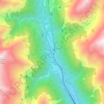
Name: Topografische Karte Arthur's Pass, Höhe, Relief.
Durchschnittliche Höhe: 1.204 m
Minimale Höhe: 706 m
Maximale Höhe: 1.834 m
Arthur's Pass township is about 5 kilometres (3.1 mi) south of the mountain pass with the same name. Its elevation is 740 metres (2,430 ft) above sea level surrounded by beech forest. The Bealey River runs through the township. The town is located 153 kilometres (95 mi) from Christchurch a 2-hour drive on State Highway 73.
Andere topografische Karten
Klicken Sie auf eine Karte, um ihre Topografie, ihre Höhe und ihr Relief anzuzeigen.
Hydra Island
New Zealand > Canterbury > Selwyn District
Hydra Island, Selwyn District, Canterbury, New Zealand
Durchschnittliche Höhe: 474 m
Hogs Back
New Zealand > Canterbury > Selwyn District
Hogs Back, Selwyn District, Canterbury, 7580, New Zealand
Durchschnittliche Höhe: 925 m
Golgotha
New Zealand > Canterbury > Selwyn District
Golgotha, Selwyn District, Canterbury, New Zealand
Durchschnittliche Höhe: 410 m
West Melton
New Zealand > Canterbury > Selwyn District
West Melton, Selwyn District, Canterbury, 7618, New Zealand
Durchschnittliche Höhe: 88 m
Mt Barker
New Zealand > Canterbury > Selwyn District
Mt Barker, Selwyn District, Canterbury, New Zealand
Durchschnittliche Höhe: 617 m
Prebbleton
New Zealand > Canterbury > Selwyn District
Prebbleton, Selwyn District, Canterbury, 7604, New Zealand
Durchschnittliche Höhe: 25 m
Rolleston
New Zealand > Canterbury > Selwyn District
Rolleston, Selwyn District, Canterbury, 7614, New Zealand
Durchschnittliche Höhe: 54 m