
Spenden
Topografische Karte Mount Oriod
Klicken Sie auf die Karte, um die Höhe anzuzeigen.
Spenden
Über diese Karte
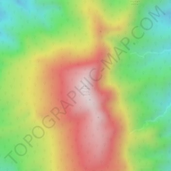
Name: Topografische Karte Mount Oriod, Höhe, Relief.
Durchschnittliche Höhe: 873 m
Minimale Höhe: 563 m
Maximale Höhe: 1.164 m
Spenden
Andere topografische Karten
Klicken Sie auf eine Karte, um ihre Topografie, ihre Höhe und ihr Relief anzuzeigen.
Ipo Dam
Philippines > Bulacan > Norzagaray > Ipo
The spill level of the dam is at an elevation of 101 metres and it has seven radial floodgates. The watershed topography is characterised by mountainous terrain similar to the Angat Reservoir Watershed with moderate forest cover. The watershed has an area of about 70 square kilometers and receives an average…
Durchschnittliche Höhe: 174 m
Spenden
Ipo Dam
Philippines > Bulacan > Norzagaray > Ipo
The spill level of the dam is at an elevation of 101 metres and it has seven radial floodgates. The watershed topography is characterised by mountainous terrain similar to the Angat Reservoir Watershed with moderate forest cover. The watershed has an area of about 70 square kilometers and receives an average…
Durchschnittliche Höhe: 174 m