
Topografische Karte Godalming
Klicken Sie auf die Karte, um die Höhe anzuzeigen.
Godalming
Elevations vary between 36 m (118 ft) AOD by the Guildford Road Rugby Union ground and Broadwater lake at the River Wey's exit from Godalming into Peasmarsh, Shalford, and 106 m (348 ft) AOD where Quarter Mile meets Hambledon Road (both residential) in the south-east. Hurtmore Road is also residential: Upper Green/Hurtmore is at 102 m (335 ft) AOD. Immediately north and south of the town centre, steep hills reach 95 m (312 ft) AOD from 40–45 m (131–148 ft) AOD in the town centre itself.
Über diese Karte
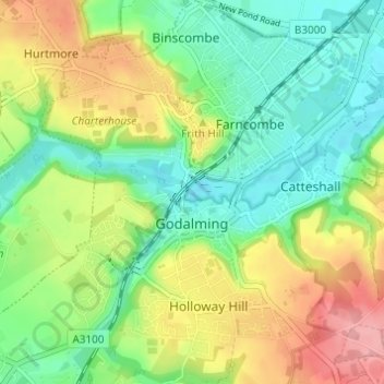
Name: Topografische Karte Godalming, Höhe, Relief.
Ort: Godalming, Waverley, Surrey, England, United Kingdom (51.16986 -0.64093 51.20806 -0.58489)
Durchschnittliche Höhe: 71 m
Minimale Höhe: 31 m
Maximale Höhe: 133 m
Andere topografische Karten
Klicken Sie auf eine Karte, um ihre Topografie, ihre Höhe und ihr Relief anzuzeigen.
Camelsdale
United Kingdom > England > Surrey > Waverley > Haslemere > Shottermill
Durchschnittliche Höhe: 166 m