
Topografische Karte Milpa Alta
Interaktive Karte
Klicken Sie auf die Karte, um die Höhe anzuzeigen.
Milpa Alta
It has an average altitude of 2,420 meters above sea level with altitudes varying between 2,300 and 3,600. It is part of the Trans-Mexican Volcanic Belt and the Sierra Chichinautzin volcanic mountain chain, which separates Mexico City from the state of Morelos. The borough is divided into three zones: Ajusco-Teuhtli, the lowest elevations, Topilejo-Milpa Alta in the medium range and Cerro-Tlicuaya at the highest elevations. The main elevations are volcanic and include Cuautzin (3,510), Tulmiac, Ocusacayo (3,220), La Comalera (3,230), San Bartolo (3,200), Tláloc (3,510), Chichinautzin (3,470), Yecahuazac, Quimixtepec, El Oclayuca (3,140), El Pajonal (3,100), El Ocotécatl (3,480), Acopiaxco (3,320), Tetzacoatl (3,310), Tehutli (2,800) Cilcuayo (3,580), Nepanapa (3,460), Texalo (3,560), Oclayuca (3,390), San Miguel (2,988) .
Über diese Karte
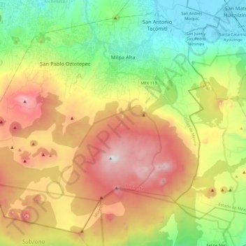
Name: Topografische Karte Milpa Alta, Höhe, Relief.
Ort: Milpa Alta, Mexico City, Mexico (19.04872 -99.16329 19.22770 -98.95239)
Durchschnittliche Höhe: 2.842 m
Minimale Höhe: 2.230 m
Maximale Höhe: 3.673 m
Andere topografische Karten
Klicken Sie auf eine Karte, um ihre Topografie, ihre Höhe und ihr Relief anzuzeigen.