
Vielen Dank für die Unterstützung dieser Website ❤️
Spenden
Spenden
Topografische Karte Alcaria Cova
Klicken Sie auf die Karte, um die Höhe anzuzeigen.
Vielen Dank für die Unterstützung dieser Website ❤️
Spenden
Spenden
Über diese Karte
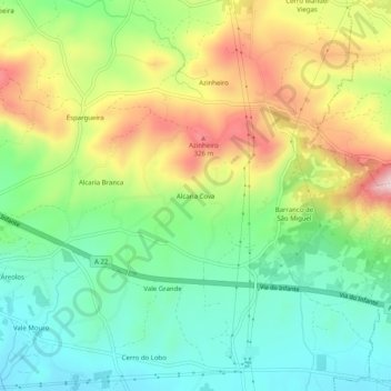
Name: Topografische Karte Alcaria Cova, Höhe, Relief.
Ort: Alcaria Cova, Conceição e Estoi, Faro, 8005-405, Portugal (37.07989 -7.87913 37.11989 -7.83913)
Durchschnittliche Höhe: 181 m
Minimale Höhe: 61 m
Maximale Höhe: 370 m
Vielen Dank für die Unterstützung dieser Website ❤️
Spenden
Spenden
Andere topografische Karten
Klicken Sie auf eine Karte, um ihre Topografie, ihre Höhe und ihr Relief anzuzeigen.