
Spenden
Topografische Karte Sungro
Klicken Sie auf die Karte, um die Höhe anzuzeigen.
Spenden
Über diese Karte
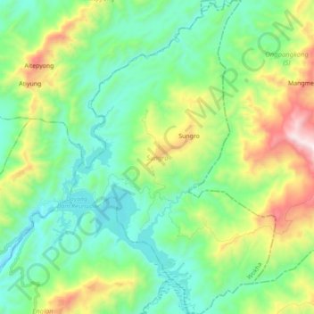
Name: Topografische Karte Sungro, Höhe, Relief.
Ort: Sungro, Wokha, Nagaland, India (26.17839 94.26879 26.33535 94.38372)
Durchschnittliche Höhe: 608 m
Minimale Höhe: 255 m
Maximale Höhe: 1.521 m
Spenden
Andere topografische Karten
Klicken Sie auf eine Karte, um ihre Topografie, ihre Höhe und ihr Relief anzuzeigen.
Kohima
India > Nagaland > Kohima Sadar
Kohima (/koʊˈhiːmə/ ; Angami Naga: Kewhira (IPA: [ˈkɛʍɪɻə]) is the capital of the Indian state of Nagaland. With a resident population of almost 100,000, it is the second largest city in the state. Kohima constitutes both a district and a municipality. The municipality covers 20 km2 (7.7 sq mi). The…
Durchschnittliche Höhe: 1.425 m
Spenden
Spenden
Spenden
Spenden
Spenden
Spenden
Kohima
India > Nagaland > Kohima Sadar
Kohima (/koʊˈhiːmə/ ; Angami Naga: Kewhira (IPA: [ˈkɛʍɪɻə])) is the capital of the North East Indian state of Nagaland. With a resident population of almost 100,000, it is the second largest city in the state. Kohima constitutes both a district and a municipality. The municipality covers 20 km2 (7.7…
Durchschnittliche Höhe: 1.425 m
Spenden