
Topografische Karte Malinau
Interaktive Karte
Klicken Sie auf die Karte, um die Höhe anzuzeigen.
Malinau
Malinau borders Nunukan Regency in the north, Tana Tidung, Bulungan, and Berau regencies in the east, East Kutai, Kutai Kartanegara, and West Kutai regencies in the south, and the Malaysian state of Sabah in the west. From its 40,088.38 square kilometers of area, Kayan Mentarang National Park consist of 24.88% of total regency's area. Other than that, other 16.97% of the regency is protected forest, and 49.69% is production forest. Topography in Malinau varies between altitude of 0 to 2,000 metres above sea level with slope between 0% to 40%. Human settlement and ricefields are mostly found between region with slope of 3% to 15%. The regency is considered located on relatively high altitude compared to its neighbouring regions.
Über diese Karte
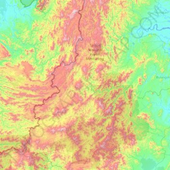
Name: Topografische Karte Malinau, Höhe, Relief.
Ort: Malinau, North Kalimantan, 77554, Indonesia (1.11404 114.56516 4.12322 116.79401)
Durchschnittliche Höhe: 627 m
Minimale Höhe: -3 m
Maximale Höhe: 2.298 m
Andere topografische Karten
Klicken Sie auf eine Karte, um ihre Topografie, ihre Höhe und ihr Relief anzuzeigen.