Geolokalisieren

Topografische Karte Wisanger

Interaktive Karte

Klicken Sie auf die Karte, um die Höhe anzuzeigen.

Über diese Karte

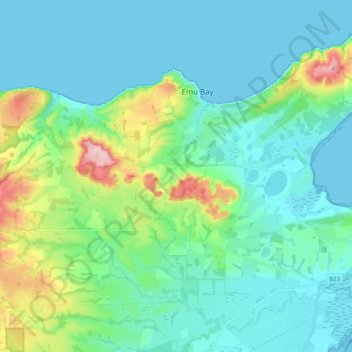
Name: Topografische Karte Wisanger, Höhe, Relief.

Ort: Wisanger, Kangaroo Island Council, South Australia, 5223, Australia (-35.67858 137.38284 -35.57920 137.58274)

Durchschnittliche Höhe: 38 m

Minimale Höhe: 0 m

Maximale Höhe: 190 m

Andere topografische Karten

Klicken Sie auf eine Karte, um ihre Topografie, ihre Höhe und ihr Relief anzuzeigen.

Kangaroo Island

Australia > South Australia > Kangaroo Island Council

Kangaroo Island, Kangaroo Island Council, South Australia, Australia

Durchschnittliche Höhe: 22 m

Flinders Chase

Australia > South Australia > Kangaroo Island Council

Flinders Chase, Kangaroo Island Council, South Australia, 5223, Australia

Durchschnittliche Höhe: 94 m

American River

Australia > South Australia > Kangaroo Island Council

American River, Kangaroo Island Council, South Australia, 5221, Australia

Durchschnittliche Höhe: 30 m

Kingscote

Australia > South Australia > Kangaroo Island Council

Kingscote, Kangaroo Island Council, South Australia, 5223, Australia

Durchschnittliche Höhe: 7 m

Cape Willoughby Conservation Park

Australia > South Australia > Kangaroo Island Council

Cape Willoughby Conservation Park, Kangaroo Island Council, South Australia, Australia

Durchschnittliche Höhe: 12 m

Nepean Bay

Australia > South Australia > Kangaroo Island Council

Nepean Bay, Kangaroo Island Council, South Australia, 5223, Australia

Durchschnittliche Höhe: 25 m