
Topografische Karte Rustenburg Ward 9
Interaktive Karte
Klicken Sie auf die Karte, um die Höhe anzuzeigen.
Über diese Karte
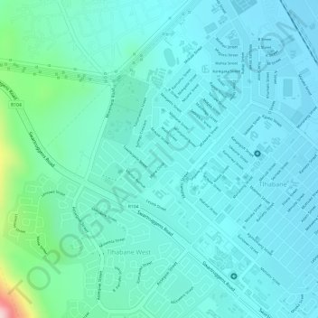
Name: Topografische Karte Rustenburg Ward 9, Höhe, Relief.
Durchschnittliche Höhe: 1.207 m
Minimale Höhe: 1.158 m
Maximale Höhe: 1.442 m
Andere topografische Karten
Klicken Sie auf eine Karte, um ihre Topografie, ihre Höhe und ihr Relief anzuzeigen.
Kgaswane Mountain Nature Reserve
RSA > North West > Rustenburg Local Municipality
Kgaswane Mountain Nature Reserve, Pegierae Hiking Trail, Rustenburg Ward 16, Rustenburg Local Municipality, Bojanala Platinum District Municipality, North West, RSA
Durchschnittliche Höhe: 1.306 m
Olifantsnek Dam
RSA > North West > Rustenburg Local Municipality
Olifantsnek Dam, Rustenburg Local Municipality, Bojanala Platinum District Municipality, North West, RSA
Durchschnittliche Höhe: 1.246 m