Geolokalisieren

Topografische Karte Lago

Klicken Sie auf die Karte, um die Höhe anzuzeigen.

Über diese Karte

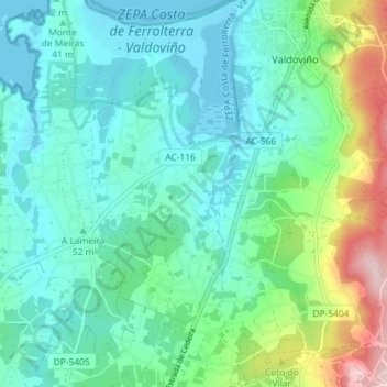
Name: Topografische Karte Lago, Höhe, Relief.

Ort: Lago, Valdoviño, Ferrol, La Coruña, Galicia, 15551, España (43.56277 -8.18669 43.61476 -8.14159)

Durchschnittliche Höhe: 69 m

Minimale Höhe: -2 m

Maximale Höhe: 307 m

Andere topografische Karten

Klicken Sie auf eine Karte, um ihre Topografie, ihre Höhe und ihr Relief anzuzeigen.

Atios

España > Galicia > Ferrol > Valdoviño

Durchschnittliche Höhe: 68 m

Figueredo

España > Galicia > Ferrol > Valdoviño

Durchschnittliche Höhe: 47 m

Broño

España > Galicia > Ferrol > Valdoviño

Durchschnittliche Höhe: 32 m

Cotelo

España > Galicia > Ferrol > Valdoviño

Durchschnittliche Höhe: 96 m

Montefaro

España > Galicia > Ferrol > Valdoviño

Durchschnittliche Höhe: 46 m

A Penela

España > Galicia > Ferrol > Valdoviño

Durchschnittliche Höhe: 109 m

Lanzós

España > Galicia > Ferrol > Valdoviño

Durchschnittliche Höhe: 82 m