
Topografische Karte Garessio
Interaktive Karte
Klicken Sie auf die Karte, um die Höhe anzuzeigen.
Über diese Karte
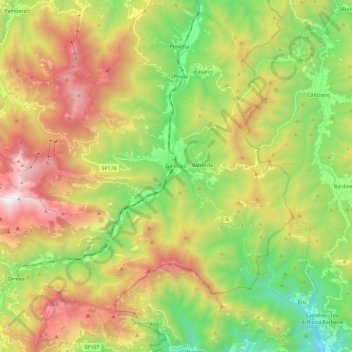
Name: Topografische Karte Garessio, Höhe, Relief.
Ort: Garessio, Cuneo, Piedmont, 12075, Italy (44.14164 7.86262 44.25424 8.09728)
Durchschnittliche Höhe: 961 m
Minimale Höhe: 129 m
Maximale Höhe: 2.112 m
Andere topografische Karten
Klicken Sie auf eine Karte, um ihre Topografie, ihre Höhe und ihr Relief anzuzeigen.
Strepeis
Italy > Piedmont > Cuneo > Bagni di Vinadio
Strepeis, Bagni di Vinadio, Vinadio, Cuneo, Piedmont, Italy
Durchschnittliche Höhe: 1.758 m
San Bernolfo
Italy > Piedmont > Cuneo > Vinadio
San Bernolfo, Vinadio, Cuneo, Piedmont, Italy
Durchschnittliche Höhe: 2.036 m
San Rocco Castagnaretta
Italy > Piedmont > Cuneo > Cuneo > San Rocco Castagnaretta
San Rocco Castagnaretta, Cuneo, Piedmont, 12100, Italy
Durchschnittliche Höhe: 569 m
Limone Piemonte
Limone Piemonte, Cuneo, Piedmont, 12015, Italy
Durchschnittliche Höhe: 1.619 m