
Topografische Karte Raigarh
Interaktive Karte
Klicken Sie auf die Karte, um die Höhe anzuzeigen.
Über diese Karte
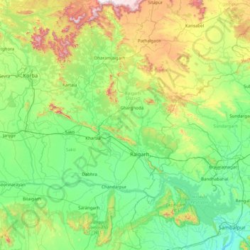
Name: Topografische Karte Raigarh, Höhe, Relief.
Ort: Raigarh, Chhattisgarh, India (21.33876 82.91979 22.78963 83.79754)
Durchschnittliche Höhe: 330 m
Minimale Höhe: 132 m
Maximale Höhe: 1.132 m
Andere topografische Karten
Klicken Sie auf eine Karte, um ihre Topografie, ihre Höhe und ihr Relief anzuzeigen.
Mahasamund
India > Chhattisgarh > Mahasamund Tahsil
Mahasamund, Mahasamund Tahsil, Mahasamund District, Chhattisgarh, 493445, India
Durchschnittliche Höhe: 291 m
Duldula
India > Chhattisgarh > Duldula Tahsil
Duldula, Duldula Tahsil, Jashpur District, Chhattisgarh, 496334, India
Durchschnittliche Höhe: 530 m
Kansabel
India > Chhattisgarh > Kansabel Tahsil
Kansabel, Kansabel Tahsil, Jashpur District, Chhattisgarh, India
Durchschnittliche Höhe: 470 m
Dantewada Tahsil
Dantewada Tahsil, Dantewada District, Chhattisgarh, India
Durchschnittliche Höhe: 503 m
Dongargarh
India > Chhattisgarh > Dongargarh Tahsil
Dongargarh, Dongargarh Tahsil, Rajnandgaon District, Chhattisgarh, 491445, India
Durchschnittliche Höhe: 356 m
Sukma
India > Chhattisgarh > Sukma Tahsil
Sukma, Sukma Tahsil, Sukma District, Chhattisgarh, 494111, India
Durchschnittliche Höhe: 219 m
Durg
India > Chhattisgarh > Durg Tahsil
Durg, Durg Tahsil, Durg District, Chhattisgarh, 491002, India
Durchschnittliche Höhe: 295 m
Kirandul
India > Chhattisgarh > Kuakonda Tahsil
Kirandul, Kuakonda Tahsil, Dantewada District, Chhattisgarh, 494556, India
Durchschnittliche Höhe: 742 m
Pathalgaon
India > Chhattisgarh > Pathalgaon Tahsil
Pathalgaon, Pathalgaon Tahsil, Jashpur District, Chhattisgarh, 496118, India
Durchschnittliche Höhe: 549 m
Simga Tahsil
Simga Tahsil, Baloda Bazar District, Chhattisgarh, India
Durchschnittliche Höhe: 269 m
Pendra
India > Chhattisgarh > Pendra Tahsil
Pendra, Pendra Tahsil, Gaurela-Pendra-Marwahi district, Chhattisgarh, 495119, India
Durchschnittliche Höhe: 594 m
Kanger
India > Chhattisgarh > Darbha Tahsil
Kanger, Darbha Tahsil, Bastar, Chhattisgarh, 494442, India
Durchschnittliche Höhe: 551 m
Bastar Tahsil
Bastar Tahsil, Bastar, Chhattisgarh, India
Durchschnittliche Höhe: 577 m
Dhamtari Tahsil
Dhamtari Tahsil, Dhamtari, Chhattisgarh, India
Durchschnittliche Höhe: 341 m
Sarangarh
India > Chhattisgarh > Sarangarh Tahsil
Sarangarh, Sarangarh Tahsil, Sarangarh Bilaigarh, Chhattisgarh, India
Durchschnittliche Höhe: 236 m
Gharghoda
India > Chhattisgarh > Gharghoda Tahsil
Gharghoda, Gharghoda Tahsil, Raigarh District, Chhattisgarh, 496111, India
Durchschnittliche Höhe: 280 m
Kota
India > Chhattisgarh > Kota Tahsil
Kota, Kota Tahsil, Bilaspur, Chhattisgarh, 495650, India
Durchschnittliche Höhe: 314 m
Raipur
India > Chhattisgarh > Raipur Tahsil
Raipur, Raipur Tahsil, Raipur District, Chhattisgarh, 493332, India
Durchschnittliche Höhe: 288 m
Kansa
India > Chhattisgarh > Dabhra Tahsil > Kansa
Kansa, Dabhra Tahsil, Janjgir-Champa, Chhattisgarh, 495688, India
Durchschnittliche Höhe: 232 m
Chini
India > Chhattisgarh > Tamnar Tahsil
Chini, Tamnar Tahsil, Raigarh District, Chhattisgarh, India
Durchschnittliche Höhe: 337 m
Raipur
India > Chhattisgarh > Raipur Tahsil > Raipur
Raipur, Raipur Tahsil, Raipur, Chhattisgarh, 493332, India
Durchschnittliche Höhe: 288 m
Raigarh
Raigarh, Raigarh District, Chhattisgarh, India
Durchschnittliche Höhe: 479 m