
Topografische Karte Kimberley
Interaktive Karte
Klicken Sie auf die Karte, um die Höhe anzuzeigen.
Über diese Karte
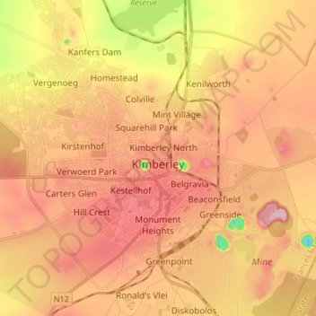
Name: Topografische Karte Kimberley, Höhe, Relief.
Durchschnittliche Höhe: 1.203 m
Minimale Höhe: 1.076 m
Maximale Höhe: 1.283 m
Kimberley is set in a relatively flat landscape with no prominent topographic features within the urban limits. The only "hills" are debris dumps generated by more than a century of diamond mining. From the 1990s these were being recycled and poured back into De Beers Mine (by 2010 it was filled to within a few tens of metres of the surface). Certain of the mine dumps, in the vicinity of the Big Hole, have been proclaimed as heritage features and are to be preserved as part of the historic industrial landscape of Kimberley.
Andere topografische Karten
Klicken Sie auf eine Karte, um ihre Topografie, ihre Höhe und ihr Relief anzuzeigen.
Sol Plaatje Local Municipality
South Africa > Northern Cape > Frances Baard District Municipality
Sol Plaatje Local Municipality, Frances Baard District Municipality, Northern Cape, South Africa
Durchschnittliche Höhe: 1.122 m
Sol Plaatje Ward 1
South Africa > Northern Cape > Frances Baard District Municipality > Sol Plaatje Local Municipality
Sol Plaatje Ward 1, Sol Plaatje Local Municipality, Frances Baard District Municipality, Northern Cape, South Africa
Durchschnittliche Höhe: 1.151 m
Hartswater
South Africa > Northern Cape > Frances Baard District Municipality > Phokwane Local Municipality
Hartswater, Phokwane Local Municipality, Frances Baard District Municipality, Northern Cape, 8570, South Africa
Durchschnittliche Höhe: 1.146 m
Barkly West
South Africa > Northern Cape > Frances Baard District Municipality > Dikgatlong Local Municipality
Barkly West, Dikgatlong Local Municipality, Frances Baard District Municipality, Northern Cape, 8375, South Africa
Durchschnittliche Höhe: 1.120 m
Windsorton Road
South Africa > Northern Cape > Frances Baard District Municipality > Magareng Local Municipality > Windsorton Road
Windsorton Road, Magareng Ward 5, Magareng Local Municipality, Frances Baard District Municipality, Northern Cape, South Africa
Durchschnittliche Höhe: 1.181 m
Phokwane Local Municipality
South Africa > Northern Cape > Frances Baard District Municipality > Phokwane Local Municipality
Phokwane Local Municipality, Frances Baard District Municipality, Northern Cape, South Africa
Durchschnittliche Höhe: 1.174 m
Jan Kempdorp
South Africa > Northern Cape > Frances Baard District Municipality > Phokwane Local Municipality
Jan Kempdorp, Phokwane Local Municipality, Frances Baard District Municipality, Northern Cape, 8550, South Africa
Durchschnittliche Höhe: 1.157 m