
Topografische Karte Glen Elder
Interaktive Karte
Klicken Sie auf die Karte, um die Höhe anzuzeigen.
Über diese Karte
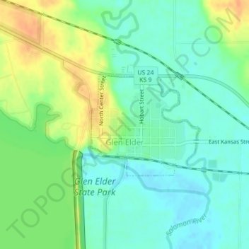
Name: Topografische Karte Glen Elder, Höhe, Relief.
Ort: Glen Elder, Mitchell County, Kansas, 67446, United States (39.49484 -98.31329 39.50591 -98.29816)
Durchschnittliche Höhe: 441 m
Minimale Höhe: 427 m
Maximale Höhe: 462 m
Andere topografische Karten
Klicken Sie auf eine Karte, um ihre Topografie, ihre Höhe und ihr Relief anzuzeigen.
Asherville
United States > Kansas > Mitchell County
Asherville, Mitchell County, Kansas, 67478, United States
Durchschnittliche Höhe: 412 m
Victor
United States > Kansas > Mitchell County
Victor, Mitchell County, Kansas, United States
Durchschnittliche Höhe: 460 m
Simpson
United States > Kansas > Mitchell County
Simpson, Mitchell County, Kansas, 67478, United States
Durchschnittliche Höhe: 407 m
Beloit
United States > Kansas > Mitchell County
Beloit, Mitchell County, Kansas, United States
Durchschnittliche Höhe: 432 m
Hunter
United States > Kansas > Mitchell County
Hunter, Mitchell County, Kansas, United States
Durchschnittliche Höhe: 495 m