
Topografische Karte Frontier County
Interaktive Karte
Klicken Sie auf die Karte, um die Höhe anzuzeigen.
Über diese Karte
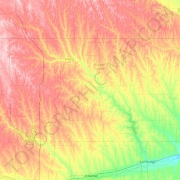
Name: Topografische Karte Frontier County, Höhe, Relief.
Ort: Frontier County, Nebraska, United States of America (40.34876 -100.78350 40.70200 -99.98161)
Durchschnittliche Höhe: 815 m
Minimale Höhe: 673 m
Maximale Höhe: 962 m
Andere topografische Karten
Klicken Sie auf eine Karte, um ihre Topografie, ihre Höhe und ihr Relief anzuzeigen.
Kearney
United States of America > Nebraska > Kearney
Kearney, Buffalo County, Nebraska, United States of America
Durchschnittliche Höhe: 662 m
Gretna
United States of America > Nebraska > Gretna
Gretna, Sarpy County, Nebraska, 68028, United States of America
Durchschnittliche Höhe: 377 m
Conestoga Lake
United States of America > Nebraska > Lincoln > Emerald
Conestoga Lake, Southwest 98th Street, Emerald, Lincoln, Lancaster County, Nebraska, 68532, United States of America
Durchschnittliche Höhe: 385 m
Mumper
United States of America > Nebraska > Mumper
Mumper, Garden County, Nebraska, United States of America
Durchschnittliche Höhe: 1.174 m
Maplewood Estates MHP
United States of America > Nebraska > Omaha > Maplewood Estates MHP
Maplewood Estates MHP, Omaha, Douglas County, Nebraska, 68164, United States of America
Durchschnittliche Höhe: 343 m
Walthill
United States of America > Nebraska > Walthill
Walthill, Thurston County, Nebraska, 68067, United States of America
Durchschnittliche Höhe: 390 m