
Topografische Karte Cache County
Interaktive Karte
Klicken Sie auf die Karte, um die Höhe anzuzeigen.
Über diese Karte
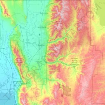
Name: Topografische Karte Cache County, Höhe, Relief.
Ort: Cache County, Utah, VS (41.36891 -112.16450 41.99952 -111.39981)
Durchschnittliche Höhe: 1.906 m
Minimale Höhe: 1.279 m
Maximale Höhe: 3.003 m
Andere topografische Karten
Klicken Sie auf eine Karte, um ihre Topografie, ihre Höhe und ihr Relief anzuzeigen.
Kanarraville
VS > Utah > Kanarraville
Kanarraville, Iron County, Utah, VS
Durchschnittliche Höhe: 1.718 m
St. George
VS > Utah > St. George
St. George, Washington County, Utah, VS
Durchschnittliche Höhe: 929 m
Zion National Park
Zion National Park, West Rim Trail, Washington County, Utah, VS
Durchschnittliche Höhe: 1.877 m
Capitol Reef National Park
Capitol Reef National Park, Notom To Oak Creek Road, Garfield County, Utah, VS
Durchschnittliche Höhe: 1.963 m
Canyonlands National Park
Canyonlands National Park, Wayne County, Utah, VS
Durchschnittliche Höhe: 1.640 m