
Topografische Karte Riobamba
Interaktive Karte
Klicken Sie auf die Karte, um die Höhe anzuzeigen.
Über diese Karte
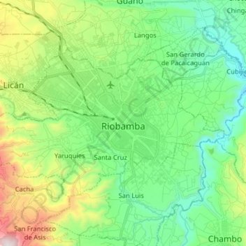
Name: Topografische Karte Riobamba, Höhe, Relief.
Ort: Riobamba, Chimborazo, Ecuador (-1.71056 -78.72359 -1.63288 -78.59549)
Durchschnittliche Höhe: 2.815 m
Minimale Höhe: 2.465 m
Maximale Höhe: 3.682 m
Riobamba (Spanish pronunciation: [rjoˈβamba], full name San Pedro de Riobamba; Quechua: Rispampa) is the capital of Chimborazo Province in central Ecuador, and is located in the Chambo River Valley of the Andes. It is 200 km (120 mi) south of Ecuador's capital Quito and located at an elevation of 2,754 m.
Andere topografische Karten
Klicken Sie auf eine Karte, um ihre Topografie, ihre Höhe und ihr Relief anzuzeigen.
Químiag
Ecuador > Chimborazo > Riobamba > Químiag
Químiag, Riobamba, Chimborazo, Ecuador
Durchschnittliche Höhe: 3.122 m