
Topografische Karte Cerro Astilleros
Interaktive Karte
Klicken Sie auf die Karte, um die Höhe anzuzeigen.
Über diese Karte
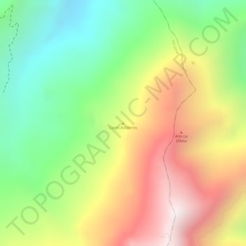
Name: Topografische Karte Cerro Astilleros, Höhe, Relief.
Ort: Cerro Astilleros, Yarumal, Norte, Antioquia, Colombia (7.03328 -75.31672 7.03338 -75.31662)
Durchschnittliche Höhe: 1.518 m
Minimale Höhe: 1.030 m
Maximale Höhe: 2.055 m
Andere topografische Karten
Klicken Sie auf eine Karte, um ihre Topografie, ihre Höhe und ihr Relief anzuzeigen.
Vereda Santa Rita
Colombia > Antioquia > Yarumal
Vereda Santa Rita, Yarumal, Norte, Antioquia, Colombia
Durchschnittliche Höhe: 2.123 m
Cuchilla Los Cuervos
Colombia > Antioquia > Yarumal
Cuchilla Los Cuervos, Yarumal, Norte, Antioquia, Colombia
Durchschnittliche Höhe: 1.924 m