
Topografische Karte Porterville
Interaktive Karte
Klicken Sie auf die Karte, um die Höhe anzuzeigen.
Über diese Karte
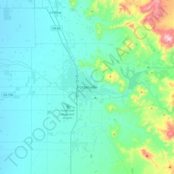
Name: Topografische Karte Porterville, Höhe, Relief.
Durchschnittliche Höhe: 222 m
Minimale Höhe: 95 m
Maximale Höhe: 1.003 m
Porterville, lying along the foothills of the Sierras at an elevation of 455 feet (139 m), is located on State Highway 65, 165 miles (266 km) north of Los Angeles, and 171 miles (275 km) east of the Pacific Coast. The city has a strategic central location to major markets and a ready access to major transportation routes.