
Topografische Karte Adlington
Klicken Sie auf die Karte, um die Höhe anzuzeigen.
Über diese Karte
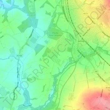
Name: Topografische Karte Adlington, Höhe, Relief.
Durchschnittliche Höhe: 95 m
Minimale Höhe: 56 m
Maximale Höhe: 162 m
Andere topografische Karten
Klicken Sie auf eine Karte, um ihre Topografie, ihre Höhe und ihr Relief anzuzeigen.
Coppull
United Kingdom > England > Lancashire > Chorley
The settlement has an Anglo Saxon name describing its topography derived from the Old English copp a hill top and hyll a hill. The township was variously recorded as Cophull and Cophulle in 1277, Copphull in 1351, Copthull in 1374 and Coppull from 1444.
Durchschnittliche Höhe: 79 m