
Topografische Karte Holiday Island
Interaktive Karte
Klicken Sie auf die Karte, um die Höhe anzuzeigen.
Über diese Karte
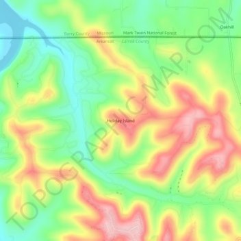
Name: Topografische Karte Holiday Island, Höhe, Relief.
Durchschnittliche Höhe: 362 m
Minimale Höhe: 278 m
Maximale Höhe: 462 m
Andere topografische Karten
Klicken Sie auf eine Karte, um ihre Topografie, ihre Höhe und ihr Relief anzuzeigen.
Rule
United States > Arkansas > Carroll County
Rule, Carroll County, Arkansas, United States
Durchschnittliche Höhe: 432 m
Urbanette
United States > Arkansas > Carroll County
Urbanette, Carroll County, Arkansas, United States
Durchschnittliche Höhe: 382 m
Beaver
United States > Arkansas > Carroll County
Beaver, Carroll County, Arkansas, 72613, United States
Durchschnittliche Höhe: 314 m
Blue Eye, AR
United States > Arkansas > Carroll County
Blue Eye, AR, Carroll County, Arkansas, United States
Durchschnittliche Höhe: 381 m
Oak Grove
United States > Arkansas > Carroll County
Oak Grove, Carroll County, Arkansas, 72616, United States
Durchschnittliche Höhe: 390 m
Eureka Springs
United States > Arkansas > Carroll County
Eureka Springs, Carroll County, Arkansas, 72632, United States
Durchschnittliche Höhe: 411 m
Eureka Springs
United States > Arkansas > Carroll County > Eureka Springs
Eureka Springs, Carroll County, Arkansas, 72632, United States
Durchschnittliche Höhe: 417 m
Maple
United States > Arkansas > Carroll County > Maple
Maple, Carroll County, Arkansas, United States
Durchschnittliche Höhe: 394 m
Green Forest
United States > Arkansas > Carroll County
Green Forest, Carroll County, Arkansas, 72638, United States
Durchschnittliche Höhe: 412 m
Coin
United States > Arkansas > Carroll County > Coin
Coin, Carroll County, Arkansas, United States
Durchschnittliche Höhe: 368 m
Berryville
United States > Arkansas > Carroll County
Berryville, Carroll County, Arkansas, 72616, United States
Durchschnittliche Höhe: 378 m