
Topografische Karte Entrèves
Interaktive Karte
Klicken Sie auf die Karte, um die Höhe anzuzeigen.
Über diese Karte
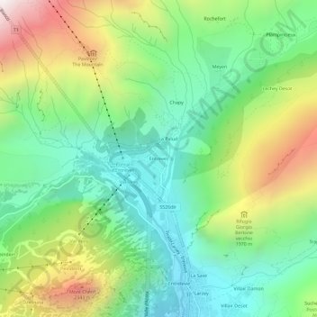
Name: Topografische Karte Entrèves, Höhe, Relief.
Ort: Entrèves, Courmayeur, Aosta Valley, 11013, Italy (45.79585 6.94266 45.83585 6.98266)
Durchschnittliche Höhe: 1.702 m
Minimale Höhe: 1.192 m
Maximale Höhe: 2.639 m
Andere topografische Karten
Klicken Sie auf eine Karte, um ihre Topografie, ihre Höhe und ihr Relief anzuzeigen.
Pointe Helbronner / Punta Helbronner
Italy > Aosta Valley > Courmayeur
Pointe Helbronner / Punta Helbronner, Courmayeur, Aosta Valley, Italy
Durchschnittliche Höhe: 3.072 m
Pussey
Italy > Aosta Valley > Courmayeur
Pussey, Courmayeur, Aosta Valley, 11013, Italy
Durchschnittliche Höhe: 1.561 m
Pic Eccles
Italy > Aosta Valley > Courmayeur
Pic Eccles, Courmayeur, Aosta Valley, Italy
Durchschnittliche Höhe: 3.722 m
Larzey
Italy > Aosta Valley > Courmayeur > Larzey
Larzey, Courmayeur, Aosta Valley, 11013, Italy
Durchschnittliche Höhe: 1.596 m
Ghiacciaio del Miage
Italy > Aosta Valley > Courmayeur > Arp Vielle inferiore
Ghiacciaio del Miage, Lungolago Miage, Arp Vielle inferiore, Courmayeur, Aosta Valley, Italy
Durchschnittliche Höhe: 2.911 m