
Spenden
Topografische Karte Lourmarin
Klicken Sie auf die Karte, um die Höhe anzuzeigen.
Spenden
Über diese Karte
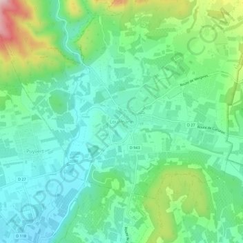
Name: Topografische Karte Lourmarin, Höhe, Relief.
Durchschnittliche Höhe: 259 m
Minimale Höhe: 156 m
Maximale Höhe: 531 m
Spenden
Andere topografische Karten
Klicken Sie auf eine Karte, um ihre Topografie, ihre Höhe und ihr Relief anzuzeigen.
Avignon
France > Provence-Alpes-Côte d'Azur > Vaucluse
Enclosed by the city walls, the Rocher des Doms is a limestone elevation of Urgonian type, 35 metres high[18] (and therefore safe from flooding of the Rhone which it overlooks) and is the original core of the city. Several limestone massifs are present around the commune (the Massif des Angles,…
Durchschnittliche Höhe: 39 m
Spenden
Spenden
Spenden
Spenden
Spenden
Spenden
Le Rhône - Bras Mort de la Barthelasse
France > Provence-Alpes-Côte d'Azur > Vaucluse > Avignon
Durchschnittliche Höhe: 24 m
Spenden
Avignon
France > Provence-Alpes-Côte d'Azur > Vaucluse
Enclosed by the city walls, the Rocher des Doms is a limestone elevation of Urgonian type, 35 metres high (and therefore safe from flooding of the Rhone which it overlooks) and is the original core of the city. Several limestone massifs are present around the commune (the Massif des Angles,…
Durchschnittliche Höhe: 39 m
Spenden
Avignon
France > Provence-Alpes-Côte d'Azur > Vaucluse
Enclosed by the city walls, the Rocher des Doms is a limestone elevation of Urgonian type, 35 metres high (and therefore safe from flooding of the Rhone which it overlooks) and is the original core of the city. Several limestone massifs are present around the commune (the Massif des Angles,…
Durchschnittliche Höhe: 39 m
Spenden
Avignon
France > Provence-Alpes-Côte d'Azur > Vaucluse
Enclosed by the city walls, the Rocher des Doms is a limestone elevation of Urgonian type, 35 metres high (and therefore safe from flooding of the Rhone which it overlooks) and is the original core of the city. Several limestone massifs are present around the commune (the Massif des Angles,…
Durchschnittliche Höhe: 39 m
Spenden
Monieux
France > Provence-Alpes-Côte d'Azur > Vaucluse
The commune is located in the zone of influence of the Mediterranean climate. The summers are hot and dry, related to the increase in altitude of the subtropical anticyclones, intersected with stormy episodes sometimes violent one. The winters are soft. Precipitations are not very frequent and rare snow. It…
Durchschnittliche Höhe: 810 m
Spenden
Spenden
Spenden
Spenden
Spenden
Spenden
Spenden