
Spenden
Topografische Karte Moho Tani
Klicken Sie auf die Karte, um die Höhe anzuzeigen.
Spenden
Moho Tani
It is a high island, with its highest elevation (520 meters) in the south, and its overall shape resembles the back of a whale.
Spenden
Über diese Karte
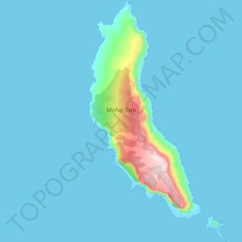
Name: Topografische Karte Moho Tani, Höhe, Relief.
Durchschnittliche Höhe: 41 m
Minimale Höhe: -5 m
Maximale Höhe: 516 m
Spenden
Andere topografische Karten
Klicken Sie auf eine Karte, um ihre Topografie, ihre Höhe und ihr Relief anzuzeigen.
Fatu Huku
France > French Polynesia > Marquesas Islands > Hiva Oa
The island is essentially a huge rock, looming steep-sided out of the ocean and rising to a flattened plateau with a maximum elevation of 361 metres (1,184 ft). Fatu Huku is the youngest of the volcanic Marquesas Islands, estimated to be only 1.3 million years old which accounts, in part, for its ruggedness as…
Durchschnittliche Höhe: 8 m