
Topografische Karte Shreveport
Interaktive Karte
Klicken Sie auf die Karte, um die Höhe anzuzeigen.
Über diese Karte
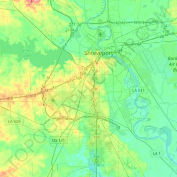
Name: Topografische Karte Shreveport, Höhe, Relief.
Ort: Shreveport, Caddo Parish, Louisiana, United States (32.33269 -93.94785 32.58987 -93.67972)
Durchschnittliche Höhe: 58 m
Minimale Höhe: 38 m
Maximale Höhe: 112 m
Shreveport is the parish seat of Caddo Parish. Portions of the city extend into neighboring Bossier Parish, bordering Bossier City. Shreveport sits on a low elevation overlooking the Red River. Western and northern portions of Shreveport have an elevation over 253 feet (77 m) above sea level. Pine forests, cotton fields, wetlands, and waterways mark the outskirts of the city. According to the United States Census Bureau in 2010, the city had a total area of 122.35 sq mi (316.88 km2), of which 107.14 sq mi (277.48 km2) is land and 15.21 sq mi (39.40 km2) is water.
Andere topografische Karten
Klicken Sie auf eine Karte, um ihre Topografie, ihre Höhe und ihr Relief anzuzeigen.
Oil City
United States > Louisiana > Caddo Parish
Oil City, Caddo Parish, Louisiana, 71061, United States
Durchschnittliche Höhe: 57 m
Southdowns
United States > Louisiana > Caddo Parish > Shreveport
Southdowns, Shreveport, Caddo Parish, Louisiana, 71118, United States
Durchschnittliche Höhe: 58 m
University Park
United States > Louisiana > Caddo Parish > Shreveport
University Park, Shreveport, Caddo Parish, Louisiana, 71106, United States
Durchschnittliche Höhe: 50 m
Cynthia Park
United States > Louisiana > Caddo Parish > Shreveport > Cynthia Park
Cynthia Park, Shreveport, Caddo Parish, Louisiana, 71109, United States
Durchschnittliche Höhe: 71 m
Hosston
United States > Louisiana > Caddo Parish > Hosston
Hosston, Caddo Parish, Louisiana, 71043, United States
Durchschnittliche Höhe: 63 m