
Topografische Karte Grand Neuweiher
Interaktive Karte
Klicken Sie auf die Karte, um die Höhe anzuzeigen.
Über diese Karte
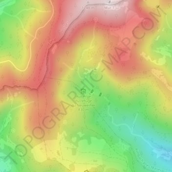
Name: Topografische Karte Grand Neuweiher, Höhe, Relief.
Durchschnittliche Höhe: 941 m
Minimale Höhe: 586 m
Maximale Höhe: 1.248 m
Andere topografische Karten
Klicken Sie auf eine Karte, um ihre Topografie, ihre Höhe und ihr Relief anzuzeigen.
Col du Ballon d'Alsace
France > Grand Est > Saint-Maurice-sur-Moselle
Col du Ballon d'Alsace, Route du Ballon d'Alsace, Saint-Maurice-sur-Moselle, Belfort, Territoire-de-Belfort, Grand Est, France métropolitaine, 88560, France
Durchschnittliche Höhe: 996 m
Tête des perches
France > Grand Est > Saint-Maurice-sur-Moselle
Tête des perches, Saint-Maurice-sur-Moselle, Épinal, Vosges, Grand Est, France métropolitaine, 88560, France
Durchschnittliche Höhe: 1.003 m
Haute Bers
France > Grand Est > Saint-Maurice-sur-Moselle
Haute Bers, Saint-Maurice-sur-Moselle, Épinal, Vosges, Grand Est, France métropolitaine, 88560, France
Durchschnittliche Höhe: 1.022 m