
Vielen Dank für die Unterstützung dieser Website ❤️
Spenden
Spenden
Topografische Karte Annecy
Klicken Sie auf die Karte, um die Höhe anzuzeigen.
Vielen Dank für die Unterstützung dieser Website ❤️
Spenden
Spenden
Annecy
Annecy has an oceanic climate (Köppen Cfb) in spite of its relatively far inland position. Influenced by its elevation, summers are rather moderate on average, although they can be highly variable with extreme heat spikes. Winters see occasional freezing temperatures, but most often stays in the single-digits during daytime with frequent cold rain. Air frosts are normal during the night and snowfall is not uncommon. Overall, winters are colder than in Chambéry.
Vielen Dank für die Unterstützung dieser Website ❤️
Spenden
Spenden
Über diese Karte
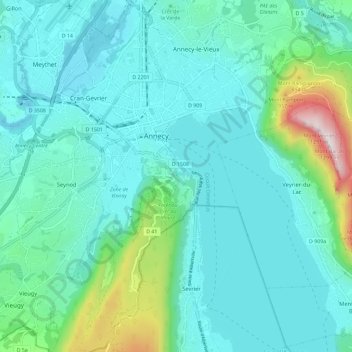
Name: Topografische Karte Annecy, Höhe, Relief.
Durchschnittliche Höhe: 554 m
Minimale Höhe: 409 m
Maximale Höhe: 1.275 m
Vielen Dank für die Unterstützung dieser Website ❤️
Spenden
Spenden