
Topografische Karte Dr Ruth Segomotsi Mompati District Municipality
Interaktive Karte
Klicken Sie auf die Karte, um die Höhe anzuzeigen.
Über diese Karte
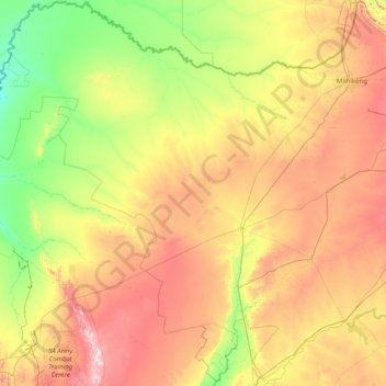
Name: Topografische Karte Dr Ruth Segomotsi Mompati District Municipality, Höhe, Relief.
Durchschnittliche Höhe: 1.234 m
Minimale Höhe: 976 m
Maximale Höhe: 1.854 m
Andere topografische Karten
Klicken Sie auf eine Karte, um ihre Topografie, ihre Höhe und ihr Relief anzuzeigen.
Rustenburg Local Municipality
RSA > North West > Rustenburg Local Municipality
Rustenburg Local Municipality, Bojanala Platinum District Municipality, North West, 0322, RSA
Durchschnittliche Höhe: 1.287 m
Manyane Resort
RSA > North West > Manyane Resort
Manyane Resort, Bojanala Platinum District Municipality, North West, 0314, RSA
Durchschnittliche Höhe: 1.106 m
Hartbeespoort Dam
RSA > North West > Madibeng Local Municipality
Hartbeespoort Dam, Madibeng Local Municipality, Bojanala Platinum District Municipality, North West, RSA
Durchschnittliche Höhe: 1.253 m
Vaal River
Vaal River, Dr Kenneth Kaunda District Municipality, North West, 8730, RSA
Durchschnittliche Höhe: 1.432 m