
Topografische Karte Michigan City
Interaktive Karte
Klicken Sie auf die Karte, um die Höhe anzuzeigen.
Über diese Karte
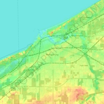
Name: Topografische Karte Michigan City, Höhe, Relief.
Ort: Michigan City, LaPorte County, Indiana, United States (41.66581 -86.93268 41.75345 -86.81609)
Durchschnittliche Höhe: 188 m
Minimale Höhe: 172 m
Maximale Höhe: 212 m
Andere topografische Karten
Klicken Sie auf eine Karte, um ihre Topografie, ihre Höhe und ihr Relief anzuzeigen.
Fish Lake
United States > Indiana > LaPorte County
Fish Lake, LaPorte County, Indiana, 46365, United States
Durchschnittliche Höhe: 215 m
Trail Creek
United States > Indiana > LaPorte County
Trail Creek, LaPorte County, Indiana, United States
Durchschnittliche Höhe: 194 m
Kingsbury
United States > Indiana > LaPorte County
Kingsbury, LaPorte County, Indiana, 46345, United States
Durchschnittliche Höhe: 227 m
Fish Creek
United States > Indiana > LaPorte County
Fish Creek, LaPorte County, Indiana, 46365, United States
Durchschnittliche Höhe: 217 m
Long Beach
United States > Indiana > LaPorte County
Long Beach, LaPorte County, Indiana, United States
Durchschnittliche Höhe: 184 m
La Porte
United States > Indiana > LaPorte County
La Porte, LaPorte County, Indiana, 46350, United States
Durchschnittliche Höhe: 247 m