
Vielen Dank für die Unterstützung dieser Website ❤️
Spenden
Spenden
Topografische Karte Mount Abu
Klicken Sie auf die Karte, um die Höhe anzuzeigen.
Vielen Dank für die Unterstützung dieser Website ❤️
Spenden
Spenden
Mount Abu
Mount Abu town, the only hill station in Rajasthan, is at an elevation of 1,220 m (4,003 ft). It has been a popular retreat from the heat of Rajasthan and neighboring Gujarat for centuries.
Vielen Dank für die Unterstützung dieser Website ❤️
Spenden
Spenden
Über diese Karte
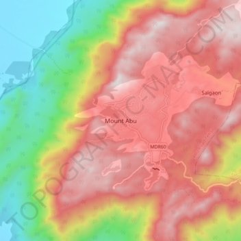
Name: Topografische Karte Mount Abu, Höhe, Relief.
Ort: Mount Abu, Abu Road Tehsil, Sirohi, Rajasthan, 307500, India (24.55243 72.66819 24.63243 72.74819)
Durchschnittliche Höhe: 914 m
Minimale Höhe: 279 m
Maximale Höhe: 1.422 m
Vielen Dank für die Unterstützung dieser Website ❤️
Spenden
Spenden