
Topografische Karte Frenchboro
Interaktive Karte
Klicken Sie auf die Karte, um die Höhe anzuzeigen.
Über diese Karte
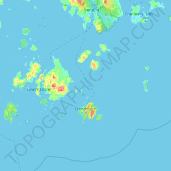
Name: Topografische Karte Frenchboro, Höhe, Relief.
Ort: Frenchboro, Hancock County, Maine, 04635, United States (44.05059 -68.49465 44.24946 -68.16839)
Durchschnittliche Höhe: 2 m
Minimale Höhe: -3 m
Maximale Höhe: 65 m
Andere topografische Karten
Klicken Sie auf eine Karte, um ihre Topografie, ihre Höhe und ihr Relief anzuzeigen.
Gouldsboro
United States > Maine > Hancock County
Gouldsboro, Hancock County, Maine, United States
Durchschnittliche Höhe: 16 m
Johns Island
United States > Maine > Hancock County > Swan's Island
Johns Island, Swan's Island, Hancock County, Maine, United States
Durchschnittliche Höhe: 0 m
Sister Islands
United States > Maine > Hancock County > Swan's Island
Sister Islands, Swan's Island, Hancock County, Maine, 04635, United States
Durchschnittliche Höhe: 9 m
Trenton
United States > Maine > Hancock County
Trenton, Hancock County, Maine, 04705, United States
Durchschnittliche Höhe: 19 m
Turtle Island
United States > Maine > Hancock County > Winter Harbor
Turtle Island, Winter Harbor, Hancock County, Maine, United States
Durchschnittliche Höhe: 1 m
Stonington
United States > Maine > Hancock County
Stonington, Hancock County, Maine, 04681, United States
Durchschnittliche Höhe: 4 m
Southwest Harbor
United States > Maine > Hancock County
Southwest Harbor, Hancock County, Maine, 04679, United States
Durchschnittliche Höhe: 21 m
Franklin
United States > Maine > Hancock County
Franklin, Hancock County, Maine, 04634, United States
Durchschnittliche Höhe: 52 m
Otter Cliffs
United States > Maine > Hancock County > Bar Harbor
Otter Cliffs, Bar Harbor, Hancock County, Maine, United States
Durchschnittliche Höhe: 13 m
Acadia National Park
United States > Maine > Hancock County > Bar Harbor
Acadia National Park, Bar Harbor, Hancock County, Maine, 04609, United States
Durchschnittliche Höhe: 9 m
Aurora
United States > Maine > Hancock County
Aurora, Hancock County, Maine, 04408, United States
Durchschnittliche Höhe: 114 m
Ellsworth
United States > Maine > Hancock County > Ellsworth
Ellsworth, Hancock County, Maine, United States
Durchschnittliche Höhe: 52 m
Carney Island
United States > Maine > Hancock County > Deer Isle
Carney Island, Deer Isle, Hancock County, Maine, United States
Durchschnittliche Höhe: 7 m
Orland
United States > Maine > Hancock County > Orland
Orland, Hancock County, Maine, United States
Durchschnittliche Höhe: 61 m
Blue Hill
United States > Maine > Hancock County
Blue Hill, Hancock County, Maine, United States
Durchschnittliche Höhe: 38 m
Bar Harbor
United States > Maine > Hancock County
Bar Harbor, Hancock County, Maine, 04609, United States
Durchschnittliche Höhe: 33 m
Bucksport (CDP)
United States > Maine > Hancock County > Bucksport
Bucksport (CDP), Bucksport, Hancock County, Maine, 04416, United States
Durchschnittliche Höhe: 46 m
Deer Isle
United States > Maine > Hancock County
Deer Isle, Hancock County, Maine, United States
Durchschnittliche Höhe: 10 m
Mount Desert
United States > Maine > Hancock County
Mount Desert, Hancock County, Maine, United States
Durchschnittliche Höhe: 31 m
Saint Helena Island
United States > Maine > Hancock County > Stonington
Saint Helena Island, Stonington, Hancock County, Maine, 04682, United States
Durchschnittliche Höhe: 12 m