
Spenden
Topografische Karte Welsford
Klicken Sie auf die Karte, um die Höhe anzuzeigen.
Spenden
Über diese Karte
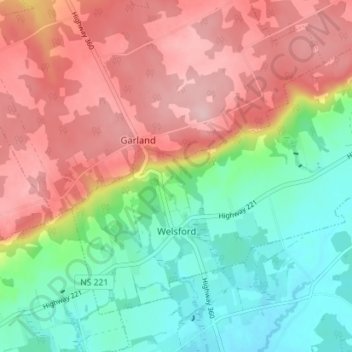
Name: Topografische Karte Welsford, Höhe, Relief.
Durchschnittliche Höhe: 129 m
Minimale Höhe: 31 m
Maximale Höhe: 238 m
Spenden
Andere topografische Karten
Klicken Sie auf eine Karte, um ihre Topografie, ihre Höhe und ihr Relief anzuzeigen.
Annapolis Valley
Canada > Nova Scotia > Municipality of the County of Kings > Auburn
Durchschnittliche Höhe: 77 m
Starrs Point
Canada > Nova Scotia > Municipality of the County of Kings > Port Williams
Durchschnittliche Höhe: 3 m
Gaspereau Mountain
Canada > Nova Scotia > Municipality of the County of Kings > Forest Hill
Durchschnittliche Höhe: 185 m
Loon Lake Channel
Canada > Nova Scotia > Municipality of the County of Kings > Aylesford Lake
Durchschnittliche Höhe: 220 m
Spenden
Gaspereau
Canada > Nova Scotia > Municipality of the County of Kings > Gaspereau
Durchschnittliche Höhe: 95 m
Cape Split
Canada > Nova Scotia > Municipality of the County of Kings > Scots Bay
Durchschnittliche Höhe: 6 m
Dalhousie Road
Canada > Nova Scotia > Municipality of the County of Kings
Durchschnittliche Höhe: 207 m