
Topografische Karte Achères
Interaktive Karte
Klicken Sie auf die Karte, um die Höhe anzuzeigen.
Über diese Karte
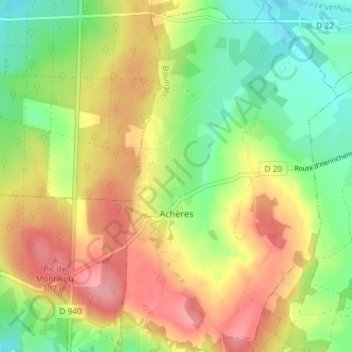
Name: Topografische Karte Achères, Höhe, Relief.
Durchschnittliche Höhe: 262 m
Minimale Höhe: 210 m
Maximale Höhe: 320 m
Andere topografische Karten
Klicken Sie auf eine Karte, um ihre Topografie, ihre Höhe und ihr Relief anzuzeigen.
La Presle
France > Centre-Val de Loire > Cher > Vesdun
La Presle, Vesdun, Saint-Amand-Montrond, Cher, Centre-Val de Loire, France métropolitaine, 18360, France
Durchschnittliche Höhe: 263 m
Lunery
France > Centre-Val de Loire > Cher
Lunery, Bourges, Cher, Centre-Val de Loire, France métropolitaine, 18400, France
Durchschnittliche Höhe: 152 m
Avord
France > Centre-Val de Loire > Cher
Avord, Bourges, Cher, Centre-Val de Loire, France métropolitaine, 18520, France
Durchschnittliche Höhe: 174 m
Ivry
France > Centre-Val de Loire > Cher > Vasselay
Ivry, Vasselay, Bourges, Cher, Centre-Val de Loire, France métropolitaine, 18110, France
Durchschnittliche Höhe: 159 m
Cornusse
France > Centre-Val de Loire > Cher > Cornusse
Cornusse, Saint-Amand-Montrond, Cher, Centre-Val de Loire, France métropolitaine, 18350, France
Durchschnittliche Höhe: 194 m
Rians
France > Centre-Val de Loire > Cher
Rians, Bourges, Cher, Centre-Val de Loire, France métropolitaine, 18220, France
Durchschnittliche Höhe: 186 m