
Topografische Karte Bello
Interaktive Karte
Klicken Sie auf die Karte, um die Höhe anzuzeigen.
Über diese Karte
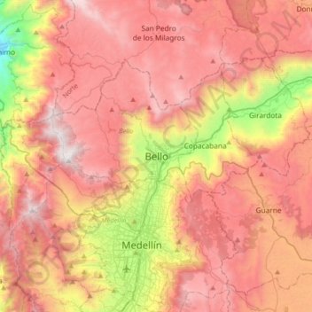
Name: Topografische Karte Bello, Höhe, Relief.
Durchschnittliche Höhe: 2.145 m
Minimale Höhe: 773 m
Maximale Höhe: 3.129 m
Andere topografische Karten
Klicken Sie auf eine Karte, um ihre Topografie, ihre Höhe und ihr Relief anzuzeigen.
Sabana Larga
Colombia > Antioquia > Bello > Bello
Sabana Larga, Bello, Valle de Aburrá, Antioquia, RAP del Agua y la Montaña, 051058, Colombia
Durchschnittliche Höhe: 2.554 m
Parque Santader
Colombia > Antioquia > Bello > Bello
Parque Santader, Manchester, Bello, Valle de Aburrá, Antioquia, RAP del Agua y la Montaña, Colombia
Durchschnittliche Höhe: 1.465 m