
Topografische Karte Warwick
Interaktive Karte
Klicken Sie auf die Karte, um die Höhe anzuzeigen.
Über diese Karte
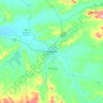
Name: Topografische Karte Warwick, Höhe, Relief.
Ort: Warwick, Queensland, 4370, Australia (-28.37632 151.87270 -28.05632 152.19270)
Durchschnittliche Höhe: 517 m
Minimale Höhe: 430 m
Maximale Höhe: 903 m
Warwick has a humid subtropical climate (Köppen Cfa) with hot summers and cool to cold winters. It is slightly cooler and less humid than the proximate southeast Queensland coast due to its inland, elevation location. Frost is present in winter. The climate bears similarities with Richmond, an inland suburb of Sydney, in central New South Wales.
Andere topografische Karten
Klicken Sie auf eine Karte, um ihre Topografie, ihre Höhe und ihr Relief anzuzeigen.
Mount Gay
Australia > Queensland > Warwick
Mount Gay, Warwick, Queensland, 4370, Australia
Durchschnittliche Höhe: 738 m
Headington Hill
Australia > Queensland > Warwick
Headington Hill, Warwick, Queensland, 4370, Australia
Durchschnittliche Höhe: 524 m