
Topografische Karte Hakuba
Interaktive Karte
Klicken Sie auf die Karte, um die Höhe anzuzeigen.
Über diese Karte
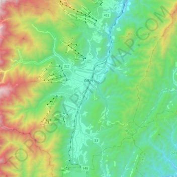
Name: Topografische Karte Hakuba, Höhe, Relief.
Ort: Hakuba, Kita-Azumi County, Nagano Prefecture, Japan (36.61393 137.75002 36.76769 137.94154)
Durchschnittliche Höhe: 1.120 m
Minimale Höhe: 528 m
Maximale Höhe: 2.578 m
The village has humid continental climate (Köppen Dfa), with cold, extremely snowy winters, and warm, rainy summers. With temperatures cooled by the elevation, monthly 24-hour average temperature ranges from −2.8 °C (27.0 °F) in January to 22.6 °C (72.7 °F) in July. Hakuba receives approximately 11 meters of snowfall annually, with most snowfall occurring in the months of January and February.
Andere topografische Karten
Klicken Sie auf eine Karte, um ihre Topografie, ihre Höhe und ihr Relief anzuzeigen.
Mount Shirouma
Japan > Kita-Azumi County > Hakuba
Mount Shirouma, Hakuba, Kita-Azumi County, Nagano Prefecture, Japan
Durchschnittliche Höhe: 2.461 m